The tiny village of Bluemont, Virginia has the distinction of being the highest community in Loudoun County at 680 ft above sea level. It has been known in the past as Snicker’s Gap, “Punkin Town,” and Snickersville. The name Bluemont was selected in 1900 to reflect the cooling nature of this gem in the Blue Ridge; it was an attempt to re-brand the area as a tourist destination.
By 1757, when Loudoun County was established, there was already a “road” through William’s gap–the dip in the Blue Ridge near Bluemont– known as the Indian Thoroughfare. The Thoroughfare ran “from Willams Cabbin in the Blew Ridge” to the Little River near present day Aldie. The road went through territory that was part of George Carter’s 1731 patent from Lord Fairfax. By 1745 the road was known as “Mountain Road.” At the Gap, however, calling it a road at that time was an exaggeration. Surveyor George Washington in 1748 decided to take Mountain Road during one of his Shenandoah Valley trips and became lost by 20 miles. Thank goodness for us he found his way through.
It was customary in those days to name the gaps through the Blue Ridge after the operator of the ferry across the Shenandoah River below the gap. But so far as anyone knows, there never was a Williams who operated the ferry below Williams Gap. The ferry there was authorized as early as 1748, and by 1760 Edward Snickers was its operator, and remained so for 30 years.
Snickers was a personal acquaintance of George Washington, who traveled the area frequently. Snickers became a wealthy landowner on both sides of Williams Gap, at one time owning about 2700 acres, including 624 acres on the eastern side of the Gap. His influence in the area left its mark, as Williams Gap eventually took his name and became Snickers Gap, and the small village at the foot of the gap (now Bluemont) was christened Snickers’ Gap in 1807 when a post office was established there. In 1826, the General Assembly incorporated the town as Snickersville.
It wasn’t Ed Snickers, however, to whom we attribute the successful settlement of Snickersville. In 1792, William Clayton bought the 624 acres that once belonged to Snickers just below Williams Gap. The 1790 advertisement in the Virginia Gazette described the acreage as a ‘valuable plantation at the foot of the Blue Ridge on the main road from Winchester to Alexandria.”
Clayton’s 1813 will described his vision to establish a town at the crossroads of the Snickers Gap Turnpike Road and the Snickers Gap-Leesburg Road. He bequeathed small ½ – 1 acre lots to his children. Clayton had already sold four lots to persons outside the family. The lots were all arranged tightly around the crossroads, making the founding of a community there nearly inevitable.
Long time town physician Dr. George Plaster wrote in his 1902 A History of Bluemont: “In the early years of the 19th century the village had grown to an active little business place, with tavern, stores, blacksmith, wheelwright and other shops of artisans, such as at that day were needed to supply the wants of a neighborhood”
Amos Clayton’s large native stone house still stands today as Clayton Hall, at the junction of Clayton Hall Road and Snickersville Turnpike. The Snickers Gap Turnpike Company used it for company meetings and events, and Amos raised his family of 12 children there.
As long as the town rested at the important crossroads of commercial travel, Snickersville remained a thriving community. The Civil War had also taken a toll on the Snickersville Turnpike. After the war, only the westernmost piece was in a condition to merit payment for passage. Dr. Plaster described the situation in the 1870s as “disastrous.” “Trade and business were drawn away and the village left stranded in a motionless eddy.” Further calamity to the commerce of the town arrived during the late 19th Century when two things happened: first, the Leesburg Road was re-routed around Bluemont taking traffic away from town, and second when the railroad company decided to stop its tracks at Round Hill.
Bluemont would have one more hurrah, however. By 1900, it had rejuvenated itself as a mountain resort town, offering an escape from the harsh summer heat of the Virginia Piedmont and Tidewater regions. Nice accommodations and genuine mountain hospitality led to such popularity in Bluemont that the W&OD Railroad decided after 25 some years to complete the last four miles of track from Round Hill and capitalize on the growing need for rail travel to the mountains during the summer. When the W&OD ceased operations in the 1930s, Bluemont once again became a quiet village off the beaten track–just as it remains today.
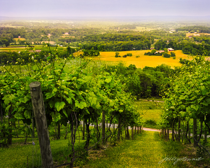
The landscape around Bluemont is beautiful at any time of the year. Being predominantly farmland, the area is beautifully pastoral, where you can find many horse and cattle pastures. Rolling hills that seem to hold the low-hanging clouds forever adds beauty and drama, and diffuse the warm sunlight in ways not common once you get away from the Blue Ridge.


For more images of the Virginia Piedmont visit J Riley Stewart Fine Art Photography
Please visit my Facebook page:
Copyright J Riley Stewart, 2012